
Note: I originally wrote this article for the General Aviation Council of Hawaii Spring 2015 newsletter. Hopefully you will find it interesting and educational as well. –JB
(For more background on weather radar basics and an overview of the different radars in Hawaii, see the GACH newsletter from Fall 2012.)
Not everything you see on a weather radar image is necessarily a weather feature. Weather radars use a series of complex algorithms to filter out energy from non-meteorological returns. In general terms, if an object is stationary, then it’s most likely not weather-related. For example, a mountain will reflect a lot of energy back to the radar. Luckily, mountains don’t move (much), and the radar will identify and filter out these types of returns. However, no algorithm is perfect, and some returns make it into the final reflectivity product even though they’re not actually precipitation. Here are a few of the more common non-meteorological returns we see in Hawaii:
Ground Clutter
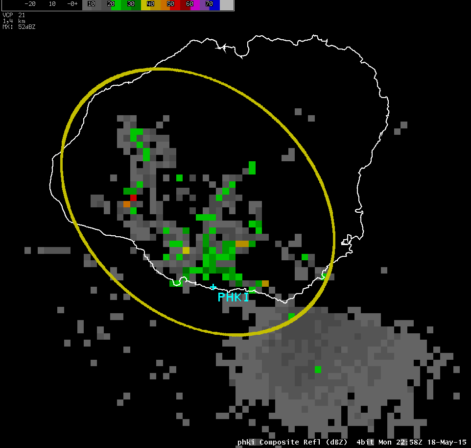
Ground clutter from the Kauai radar.
As mentioned above, the weather radar system tries to filter out known stationary objects like mountains. However, because the energy returned extends across a spectrum, it’s hard to filter out all of it without losing valid meteorological data. Because of this, there will be an area of nearly stationary returns near the radar itself. These returns are usually splotchy/speckled, and include rapid changes between reflectivity values. Ground clutter is usually greatest late at night, when the atmosphere is cool and stable.
Sea Spray
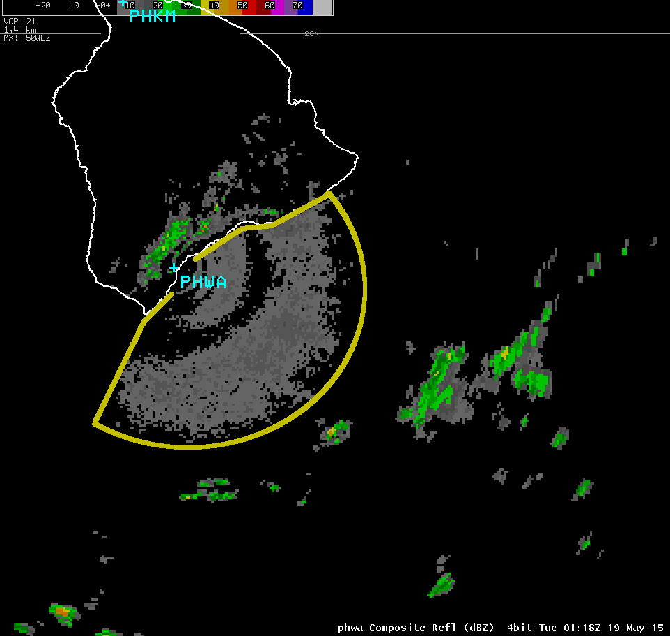
Sea spray from the South Big Island radar.
Weather radars measure the reflected energy from objects moving through the atmosphere. In most cases, those objects are precipitation droplets. However, the radar is sensitive enough to pick up sea spray when winds are strong. Energy reflected by stationary objects is relatively easy to remove, since you can filter returns with no velocity. Sea spray, on the other hand, is blown by the wind, just like precipitation. Because the spray is smaller in size, the energy returned is usually lower than most rain showers. However, stronger winds lead to greater amounts of spray, which in turn lead to higher reflectivity on radar. The amount of spray increases exponentially with the wind speed—when the wind speed doubles, the amount of spray increases eight times.
Chaff
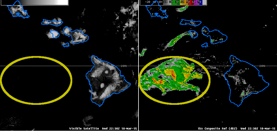
A large area of chaff. Notice there are no clouds in the area of high radar returns.
Chaff is a material used by airplanes or other airborne objects to confuse enemy radars, and is designed to be highly reflective. The idea is to saturate the air with highly reflective materials, so any energy reflected by the aircraft itself will be lost in the noise. Because weather radars use the same principles, chaff dropped by aircraft can create very strong reflectivity returns on a weather display. Chaff is easily identifiable on radar when strong, elevated returns are detected in areas of clear skies. Other times it can be embedded within actual areas of precipitation, making identification more difficult.
The Sun
Sunset spike from the North Big Island radar.
The radar emits electromagnetic energy, and measures the small fraction that reflects off precipitation. However, there’s also another object that itself emits a lot of EM energy—the sun. During sunrise and sunset, the sun is located within the line of sight to the radar dish. While the radar will filter out most of the sun’s energy, some still shows up in the reflectivity imagery. The principle is the same as with ground clutter—it’s difficult to filter out such a large signal. This is known as a sun spike, and can be seen at different elevation angles at different times (as the sun rises or sets through the radar scan area). It also changes location throughout the year, as the sun rises and sets in different locations depending on the season.
Anomalous Propagation
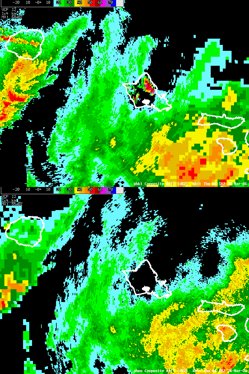
The Kauai radar (top) shows high returns over the Koolau Range due to AP. The Molokai radar (bottom shows clear conditions at the same time.
Energy transmitted by the radar travels in a straight line, but is refracted by the atmosphere. For NWS weather radars, the lowest measurement is taken with the radar dish pointing 0.5° above the horizon. Under normal conditions, at 100 nautical miles from the radar, the center of the radar beam will about 5,000 feet above the ground. During certain atmospheric conditions, the beam will refract more than normal, and end up at a lower altitude. In extreme cases, the beam can actually be bent back into the ground. This is often referred to as anomalous propagation (AP), and is an extreme form of ground clutter. When AP is present, it normally affects only one radar. In the included example, the Kauai radar shows very strong reflectivity returns over the Koolau Range. However, this is AP. The Molokai radar shows clear conditions over that area at the same time.
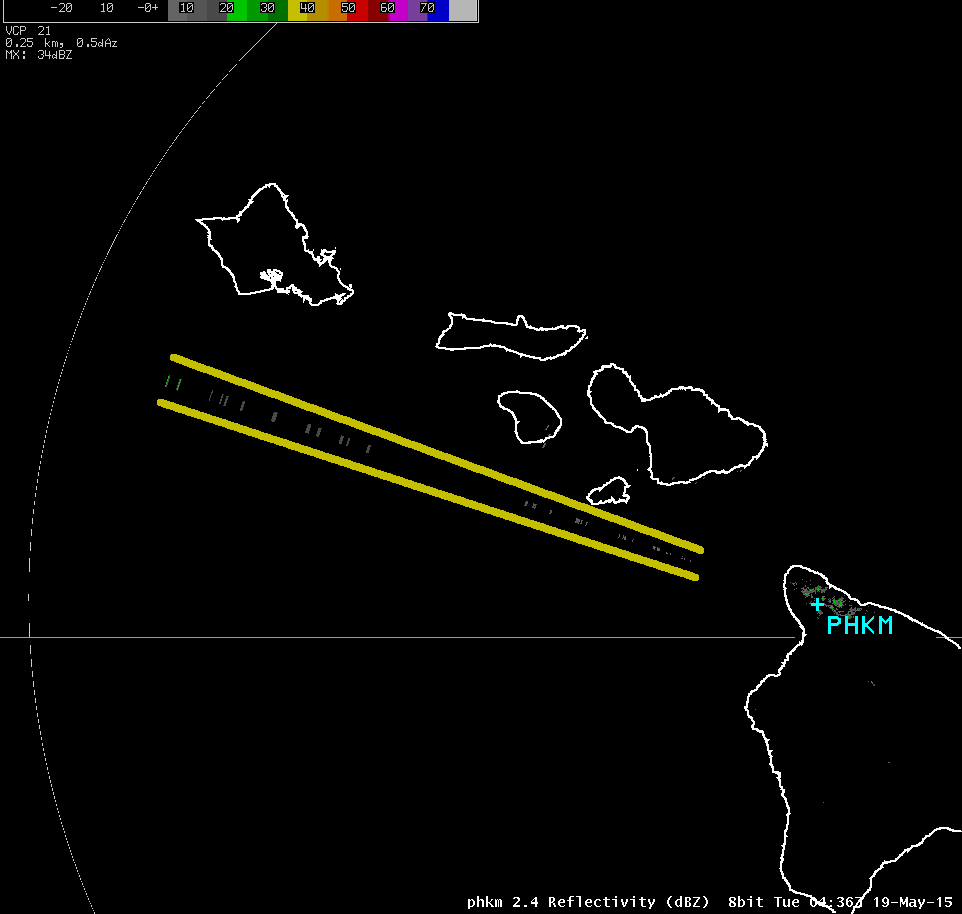
Virga/Elevated Returns
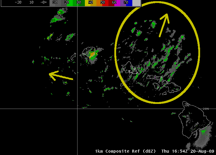
Radar returns in the yellow circle are moving to the north, while lower-altitude trade showers are moving to the west.
The last type we will discuss is slightly different from the rest. While the others are non-weather related features that are still picked up by the radar, elevated returns are actually droplets of water or ice high in the atmosphere. These droplets are either not falling (they are part of a cloud that has not started to rain yet) or are virga (precipitation that falls from clouds but evaporates before it reaches the ground). A loop of radar images can be useful to differentiate actual showers reaching the ground from elevated clouds/virga. Elevated returns are normally more uniform in appearance, and typical move in a different direction from showers that are closer to the ground. If you could animate the included example, you would see trade wind showers moving in a typical direction, and the high level returns—which did not reach the ground—moving in a different direction.
If you have questions about strange returns that you see on radar (or other questions about the weather), you can call the office at 808-973-5286. (Just remember that while we can answer your questions, we can’t provide flight briefings.) You can view the latest weather radar images for Hawaii at:
http://www.prh.noaa.gov/hnl/pages/radar.php
John Bravender
Aviation Program Manager
National Weather Service Honolulu