
Note: I originally wrote this article for the General Aviation Council of Hawaii Fall 2013 newsletter, following a particularly busy couple of weeks. Hopefully you will still find it interesting and educational. –JB
During a period of unsettled weather at the beginning of this month [October, 2013], National Weather Service spotters have reported water spouts, funnel clouds, and dust devils on many different days. We have also received a number of questions about the differences between these features and others, such as tornadoes. This is a good opportunity to review the differences between these features, and look at the hazards to aviation that they pose.
Tornadoes
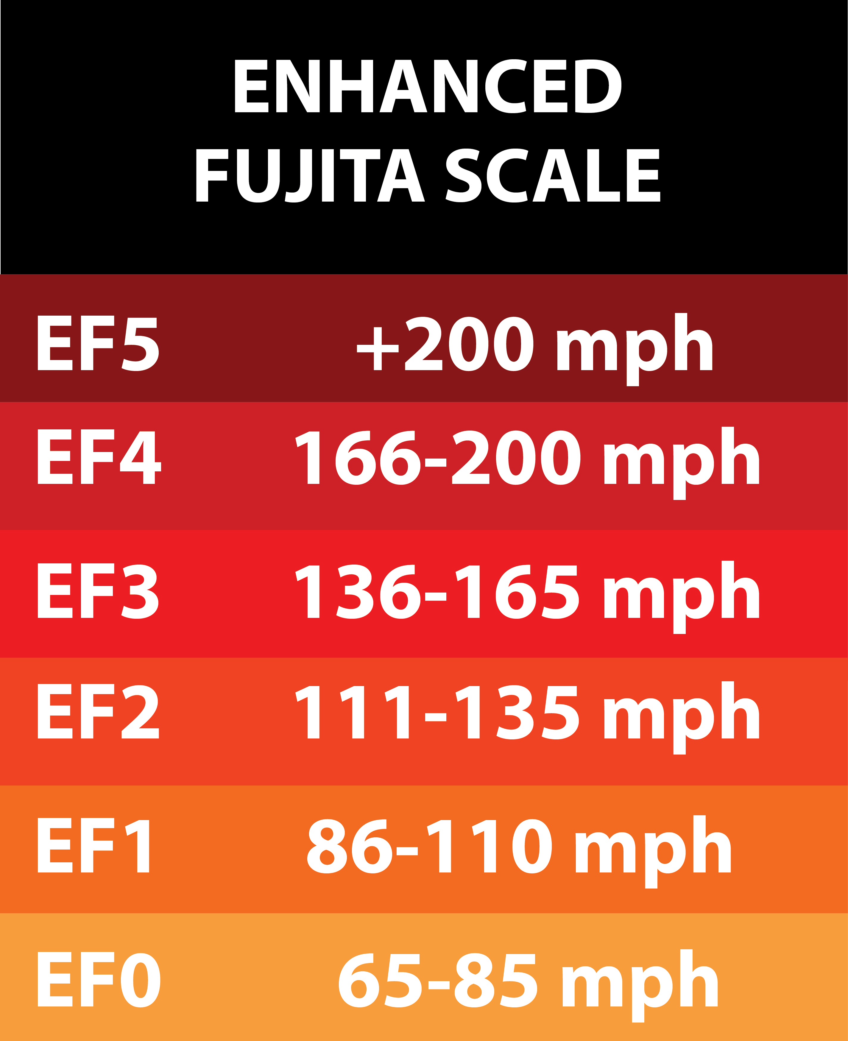 A tornado is a violently rotating column of air that extends from a cumuliform cloud to the ground. It has the potential to be one of the most intense and destructive weather features. Winds associated with a tornado can be in excess of 200 mph, which can cause total destruction of houses and even roads. Tornadoes are classified based on their damage according to the Enhanced Fujita Scale, which is a 2007 update to the original tornado classification scale developed by Dr. Tetsuya Fujita in 1971. The EF Scale divides tornado intensity into six categories from EF-0 to EF-5, with wind speeds estimated based on observed damage. (Because the intensity is based on a damage survey, there is never an explicit forecast intensity for a tornado like there is with a hurricane.)
A tornado develops when a larger-scale rotation in the atmosphere contracts down to a much smaller scale. Just as figure skaters spin faster when they bring their arms tight into their body, the rotating column will spin faster as it becomes smaller. There are two general categories of tornadoes, depending on whether the rotation develops down from cloud level or up from the ground level.
Supercell Tornadoes
Also known as “descending” tornadoes, these develop from a thunderstorm that is already rotating. The rotation at cloud level, known as a mesocyclone, is an important precursor to tornado development. The strongest and most damaging tornadoes are supercell tornadoes. These tornadoes tend to form when there is high instability and large wind shear (change of wind with height, veering clockwise as you move from the surface to the middle atmosphere). From a warning standpoint, it is possible to see the larger cloud-level rotation on radar, which can be used to issue a tornado warning before a tornado touches down.
Non-supercell Tornadoes
Also known as “non-descending” tornadoes, these tend to form from developing cumulus or towering cumulus clouds, which later develop into thunderstorms. There is usually an existing low-level boundary that provides the spin necessary for the tornado to form. In Hawaii, these typically form along sea breeze fronts. Because they develop during the initial strong updraft, the clouds that these tornadoes develop from typically have a flat, dark base and show a rapid increase in radar returns. Because the rotation develops from the ground upward, it is nearly impossible to see on radar before a tornado develops. Non-supercell tornadoes usually do not last as long as supercell tornadoes, and tend to be weaker (generally EF2 or less).
Waterspouts
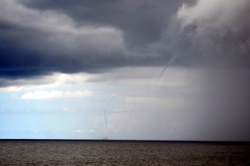
Waterspout near Tracks Beach, Oahu, 10/14/13. Photo by Robert Wood, via Hawaii News Now.
In general terms, a waterspout is a tornado that occurs over water. Most waterspouts are similar to non-supercell tornadoes—the rotation develops upward and they tend to be weaker and have a relatively short duration. However, supercell tornadoes can develop over water, and they are also called waterspouts. If a waterspout moves on land, it becomes a tornado and will prompt the NWS to issue a tornado warning.
Funnel Clouds
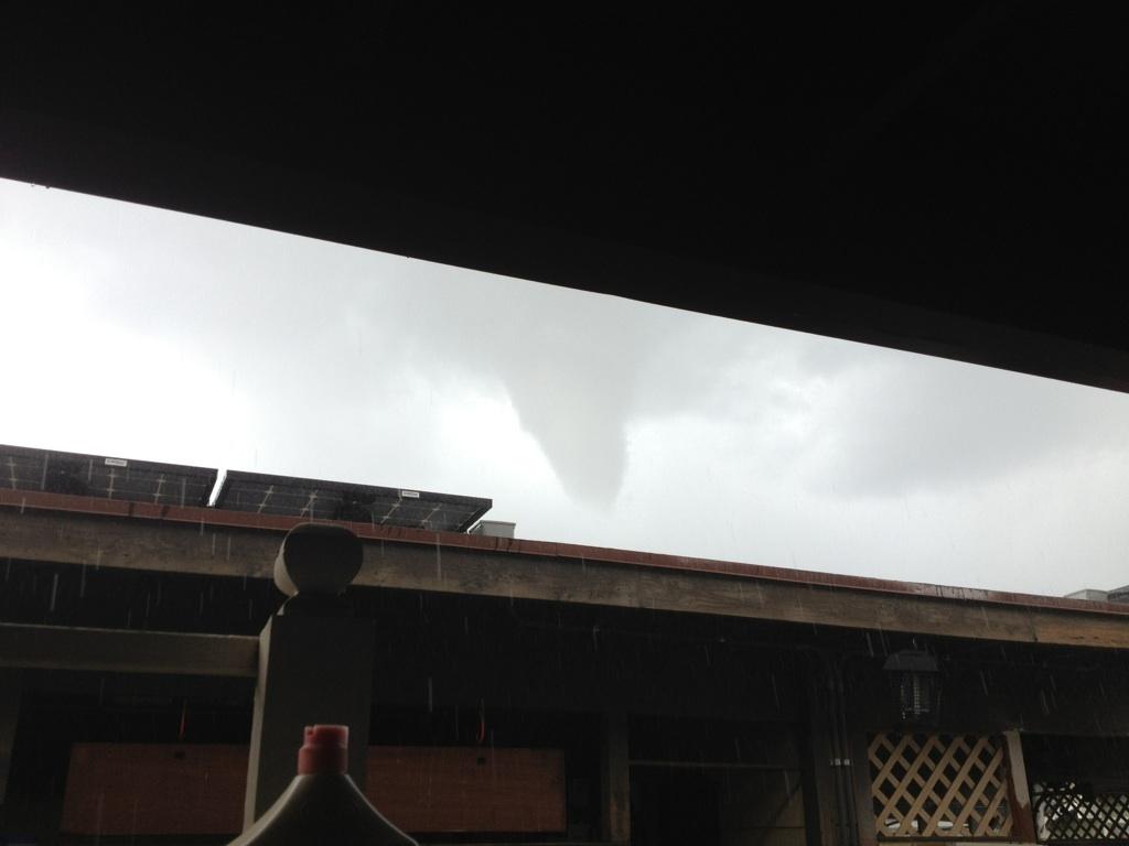
Funnel cloud near Mililani, Oahu, 10/12/13.
Funnel clouds are rotating columns of air that do not extend all the way to the surface. If they do reach the surface, they become tornadoes (over land) or waterspouts (over water). Supercell tornadoes begin as funnel clouds, although not all funnel clouds that develop in supercells ultimately become tornadoes. Funnel clouds may also develop from cumulus or towering cumulus clouds, if there is enough rotation in the atmosphere. These types of funnel clouds typically do not reach the surface
Dust Devils

Dust devil seen from Kula, Maui, 8/19/13. Photo by Justin
Offerman, via The Maui News.
Dust devils are somewhat different from the other features we have talked about up to this point. While the other features have been associated with clouds, dust devils are not. They develop due to strong heating of the near-surface layer. They occur on days with light winds and an unstable atmosphere, when there are typically strong thermals. Dust devils form in a method similar to non-supercell tornadoes, where preexisting spin is lifted by an updraft and contracts to a small scale. However, the atmosphere is typically dry, and clouds do not form with the updraft. Instead, these columns are visible because of dust that is picked up by the wind. The dust column itself rarely extends above 3,000 feet, but the rotating updraft usually extends to the top of the unstable layer, which can be in excess of 10,000 feet. Also, the rotating column is only visible when there are small dust particles that can be lifted into the air. Even if one dust devil is visible, there may be others nearby that did not pick up any dust. For example, an updraft developing over a dry field may be visible but one developing over a parking lot may not.
Hazards to Aviation
Tornadoes, water spouts, and funnel clouds all feature strong winds and violent updrafts that are extremely dangerous to aircraft. Even without these features, the thunderstorms and towering cumulus clouds that precede them are full of their own hazards, including extreme turbulence, icing, and potential hail.
Dust devils are not as intense, but still present their own hazards, especially to smaller general aviation aircraft. A 2005 review of NTSB reports identified as many as 97 incidents between 1982 and 2004 where dust devils may have been a proximate cause for serious aircraft damage, injuries, and a few fatalities. Most encounters occurred in the desert southwest, where dust devils are most common, and most incidents occurred during take-off or landing.
Warning Products
The National Weather Service issues a number of warning products for these different features:
Tornado Warning: Issued for land areas when a tornado is imminent or occurring, based on a combination of radar imagery, environmental data, and spotter reports.
Special Marine Warning: Issued for coastal waters (from land out to 40 nautical miles from shore) when a waterspout is imminent or occurring.
Special Weather Statement: Issued when there is a potential for funnel clouds. If a funnel cloud is expected to reach the ground, or spotter reports indicate that it has reached the ground, a tornado warning will be issued.
These products are only issued when they are needed during hazardous weather. When they are issued, they will be available through the WFO Honolulu website.
John Bravender
Aviation Program Manager
National Weather Service Honolulu