
An Argument for a Protected Bike Lane on the Right-Hand Side of the Road
As part of its ongoing effort to construct a minimum grid for cyclists, the City and County of Honolulu has proposed a new protected bike lane along South Street. This will be one of the first mauka/makai routes to feed into the King Street Protected Bike Lane. The original proposal for the South Street project is for the lane to be located on the ewa side of the road, which, similar to King Street, will be on the left-hand side of the one-way portion of South Street. Just as the King Street project is a two year pilot project to evaluate the utility of a protected bike lane, the South Street project should be considered a pilot project to evaluate the utility of a right-hand side protected bike lane.

One of two loading zones on the ewa side of South Street.
I’ve already discussed the background of the left-side bike lane on King Street, including some of the hazards associated with the placement and the reasoning behind it. In addition to those drawbacks, there is another concern on South Street. Restaurant Row has a large loading zone between Auahi Street and Pohukaina Street. The tenants don’t want to lose access to this area, and cyclists don’t want delivery vehicles cutting across and at times blocking the bike lane.
There are two reasons provided in the “Design” section of the DTS page for placing the South Street Protected Bike Lane on the ewa side of the road: conflict with bus stops and conflict with vehicles turning onto King Street. Rather than placing the bike lane on the ewa side of the road to avoid these conflicts (and create more as described above), we should place it on the Diamond Head side of the road. Given the relatively short length of the South Street Protected Bike Lane, this would be a good location for a new pilot project to evaluate the following mitigation efforts.
Bus Stops
The overall length of the South Street Protected Bike Lane will be eight tenths of a mile. However, the length that would overlap with TheBus is even less, only the six tenths of a mile between Ala Moana Boulevard and King Street. There are three bus stops along this stretch of South Street: at Auahi, Halekauwila, and Kawaiahao. An ideal solution would be to construct a floating bus stop. With this design, the bus stop is on a separate island apart from the sidewalk, with pedestrians crossing the bike lane on a raised crosswalk. (The progression would be: sidewalk, bike lane, waiting area for bus stop, and then traffic lane.) However, in addition to the extra cost associated with construction of the floating “island”, it would either require removing another traffic lane or expanding into the sidewalk, neither of which are feasible in our situation.
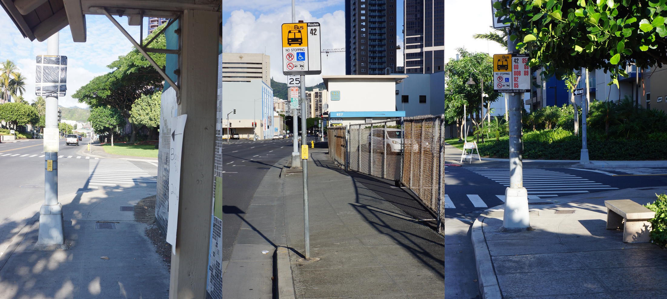
View of the three bus stops along South Street, showing their proximity to curb cutouts. (Stop #1065 at South/Auahi is temporarily closed due to construction.)
Instead, would could adopt a variation of the floating bus stop idea. Passengers would wait for the bus on the sidewalk, as they do now, instead of on a separate island. When the bus arrives, they cross the bike lane into the road/bike lane buffer zone to board the bus. When leaving the bus, passengers exit into the buffer zone, then cross the bike lane back to the sidewalk. With this setup, there is a need for curb cutouts, so that passengers who can’t step down the curb can reach the bus loading area. However, no additional construction would be needed along South Street. Two of the bus stops are located next to crosswalk cutouts at intersections, and one is located next to a driveway cutout.
As with any floating bus stop, you would have to address the area where pedestrians cross the bike lane to board the bus. Along King Street, green paint has been used to bring attention to “conflict zones”, and the same could be done here. Additional road markings to indicate an approaching bus stop could used to heighten the awareness of cyclists. A yield symbol or text such as “Bus stop” or “Yield to Ped” could be painted on the ground on either side of the stops.
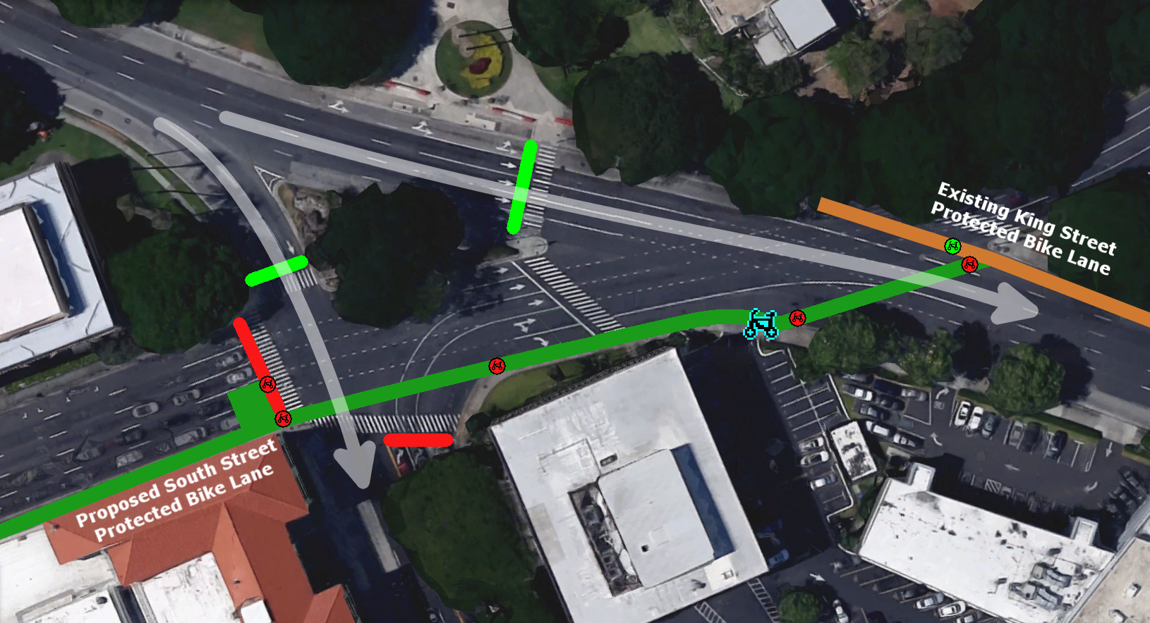
King Street Intersection

View from King Street looking toward South Street. This is the location of the proposed bicycle-specific traffic light. This light will turn green in sync with the traffic light on Kapiolani.
The intersection in question is not a simple one: South Street turns into Alapai Street, and Kapiolani Boulevard splits off from King Street. In each traffic light cycle, King, Kapiolani, and South each receive a green light in turn. I travel from the King Street Protected Bike Lane to the Civic Center Bike Path many times a week, and often have a chance to sit and watch traffic at this light. In my experience, much of the traffic heading ewa-bound on Kapiolani turns onto Alapai, not onto King Street. (This would be a round-about route to get to King, since they’d nearly be doing a U-turn and could have used a different road, such as Cooke, to avoid the extra lights and traffic.) Given this traffic pattern, there would be little impact to add a bicycle-specific traffic light on the Diamond Head side of the King/South intersection that allows cyclists to cross King Street while the Kapiolani light is green.
The timing of the traffic lights works out well for cyclists traveling from King Street to South Street: during a Kapiolani green light, they will cross King to the short block between King and Kapilani. When the South Street light turns green, they will cross Kapiolani and continue along South Street. It is slightly slower for cyclists traveling from South Street to King Street, since they would have to wait through an extra traffic light if they wish to remain in a protected bike lane (i.e., not shift into a traffic lane). With a green light on South Street, they will cross Kapiolani and wait in the short block between Kapiolani and King while the King Street light turns green. When the Kapiolani light turns green, they can proceed across King Street. In addition, a bike box could also be added on South Street at the Kapiolani light. This way, more experienced cyclists could shift from the protected bike lane to the middle traffic lane in order to turn right with the South Street green light and immediately join the King Street Protected Bike Lane.
A Picture is Worth a Thousand Words
The following images show the proposed transition to and from the South Street Protected Bike Lane. Each background image shows part of the traffic light cycle, which proceeds with green lights for King Street, Kapiolani Boulevard, and South Street in that order. White arrows indicate vehicular traffic. Blue arrows and bicycle indicate bicycle movement.
Transition from King Street to South Street Protected Bike Lane
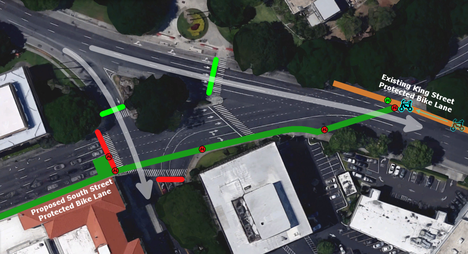
While heading ewa-bound on King Street, stop before crossing Alapai Street and wait to cross King Street.
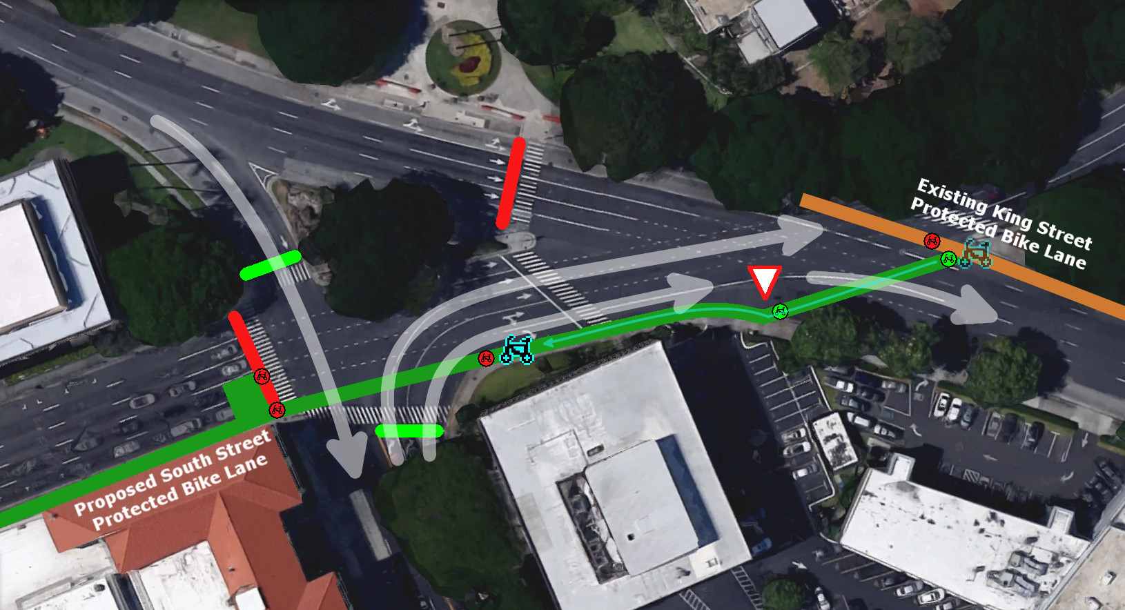
When the bicycle traffic light turns green, cross King Street. Any cars turning from Kapiolani Boulevard should yield, but ride with caution. Proceed along the bike path and wait to cross Kapiolani Boulevard.
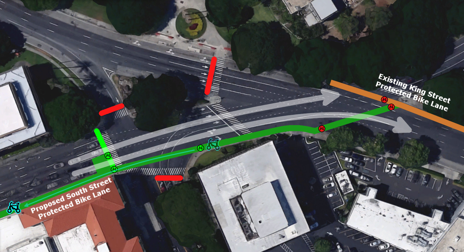
When the bicycle traffic light turns green, cross Kapiolani Boulevard and proceed down the South Street Protected Bike Lane.
Transition from South Street to King Street Protected Bike Lane

While heading ewa-bound on King Street, stop and wait to cross King Street. You can stay in the protected bike lane or join the traffic lane.

When the bicycle traffic light turns green, cross Kapiolani Boulevard. Proceed along the bike lane and wait to cross King Street. Cyclists in the traffic lane will proceed across Kapiolani and King, and join the King Street Protected Bike Lane.
Wait at the red light for King Street vehicle traffic to proceed.

When the bicycle traffic light turns green, cross King Street. Any cars turning from Kapiolani Boulevard should yield, but ride with caution. Proceed down the King Street Protected Bike Lane.