
The Summer 2016 newsletter article on trade wind inversions referenced the weather balloons we launch twice a day from Lihue and Hilo, which measure winds aloft in addition to temperature and moisture. In this article we’ll look at two additional sources of wind information: radar wind observations and the automated winds aloft forecasts.
Multi-Modal Transportation
There’s a scene in Christopher Buckley’s “Thank You For Smoking” where Nick Naylor explains his job to his son Joey, and as an example starts a debate with him as to whether chocolate or vanilla ice cream is better. Nick’s response takes the argument off the rails (which was his point), but helps me to understand something about my transportation options.
Convertible Cargo Bike
We want a cargo bike. It’s been something we’ve thought about for a while, especially since we got rid of our car, but the price and the bulk have always kept us from getting one. Now there’s an option that we can’t pass up: The LIFT carrier that turns your regular bike into a front-loading cargo bike. They just launched their Kickstarter campaign, and it’s one of the first Kickstarters that I jumped on early enough to score one of the super-early bird specials. (Yay for me; hurry up for you…)
Trade Wind Inversions
In the Winter 2014 newsletter, I talked about trade winds and briefly touched on trade wind inversions. Inversions have a big impact on the weather we see in Hawaii, and knowing more about them may be of interest to pilots.
What Is An Inversion?
Temperature normally decreases with height in the atmosphere. (The higher you go, the colder it gets.) For dry air, the temperature drops about 5.4°F for every 1000 feet, or about 9.8°C for every kilometer. An inversion is a layer where the temperature either remains the same or increases with height. It is the result of an outside force, such as a change in airmass along a front where warm air overruns cold air. The typical driving force we see in Hawaii associated with the trade winds is due to sinking air associated with high pressure systems.
Low Level Wind Shear
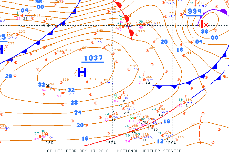
Surface analysis from 2 pm HST 2/16/16 showing strong high pressure northwest of Hawaii.
On February 16th, 2016, a 1037mb high northwest of the state brought strong and gusty northeast trade winds to the islands. We received many reports of low-level wind shear, some which we were due to non-convective wind shear and some of which were due to convective mixing and gusty winds. What are the different types of wind shear, when is wind shear included in a TAF, and what can you do to mitigate the risk from it when you fly?
Proposal to Undermine Complete Streets
There is a bill under consideration by the Honolulu City Council that will effectively undo the Complete Streets ordinance enacted by the council in 2012. Bill 84 (2015) would require any money to be spent on bikeways or complete street improvements to be specifically identified as a project in the executive capital budget ordinance. This would severely limit the options of the city for adding improvements, since many recent complete street projects have been accomplished within the existing operating budget. Since the whole point of the “Complete Streets” policy is to look for opportunities in every transportation project, this bill would negate Honolulu’s “Complete Streets” ordinance.
Are Sharrows Useful?
I had always considered Shared Lane Markings, or sharrows, a cop-out, something that localities add when they want to look like they’re doing something to enhance cycling infrastructure but don’t want to make any actual changes. My cousin recently sent me this article, which in turn was based on this study that compared ridership and injuries before and after the addition of bike lanes or sharrows. Based on data about bike commuters in Chicago, the study found that the addition of bike lanes led to an increase in ridership and a decrease in injuries, while the addition of sharrows led to minimal changes compared with roads that had no changes in markings.
This started me thinking about sharrows in a larger context, and wondering whether they could have a negative impact on cyclists. For example, Hawaii law grants a bicycle the same rights as a car on a roadway (§291C-142). However, would sharrows on some roads lead drivers to the mistaken belief that cyclists are not allowed to ride on other roads that don’t have them? After giving this some thought, I’m of the mind that sharrows can be useful when used appropriately, but we shouldn’t consider them a major infrastructure improvement.
South Street Protected Bike Lane: Right or Left Side?
An Argument for a Protected Bike Lane on the Right-Hand Side of the Road
As part of its ongoing effort to construct a minimum grid for cyclists, the City and County of Honolulu has proposed a new protected bike lane along South Street. This will be one of the first mauka/makai routes to feed into the King Street Protected Bike Lane. The original proposal for the South Street project is for the lane to be located on the ewa side of the road, which, similar to King Street, will be on the left-hand side of the one-way portion of South Street. Just as the King Street project is a two year pilot project to evaluate the utility of a protected bike lane, the South Street project should be considered a pilot project to evaluate the utility of a right-hand side protected bike lane.
Left-Side Bike Lane?
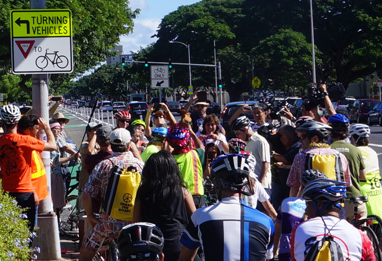
Ceremonial ribbon cutting to open the King Street Protected Bike Lane. December 6, 2014.
It’s been over a year since the City and County of Honolulu installed Hawaii’s first protected bike lane. After riding it several times a week since it was added, I’ve noticed a few things. First, after a somewhat frustrating break-in period, bicyclists and drivers have gotten better at anticipating each others actions, and both types of traffic seem to move more smoothly. However, there are still situations that require extra caution, and they are different depending on which direction you travel in the two-way bike lane.
Meaningful Photos of 2015
 I started using Instagram in about May of 2015 after noticing that I mainly posted photos to Facebook. With time I started using it almost exclusively; even though I also share them across platforms, I tend to avoid looking at Facebook itself. As 2015 started to wind down, a number of people began posting a “Best of 2015” mosaic, showing their nine most popular photos from the year. It’s easy to do, but when, out of curiosity, I ran it for my account, I discovered a flaw. The number of “likes” you get is highly dependent on the number of hashtags you use, and the popularity of the tags. Use something popular like “lego” and you can end up with many more people looking at your image, and consequently can end up with a disproportionate number of likes.
I didn’t like the skewed rankings, and set out to create my own mosaic. At first I wanted to pick my favorite photos, but as I was looking through them my goal changed. Instead of necessarily picking out my favorites, I picked the ones that held the most meaning or represented important events. I actually surprised myself with some of my choices, since a couple pictures I thought were a given for inclusion because they were simply cool didn’t make the final cut.
Some of the images represent a deeper meaning or event beyond what it actually shown. With this in mind, I decided to include a description of what they mean to me and why I included them. Continue reading