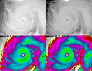
Hurricane Walaka is located just east of 170°W. It’s still located closer to NOAA’s old GOES-West satellite than to JMA’s Himawari, but the newer satellite has the better resolution to make up for the distance.
GOES-West is located near 135°W and Himawari is located just this side of 140°E. Doing the math, Walaka is about 35 degrees longitude away from the NOAA satellite and about 50 degrees longitude away from the JMA satellite. However, since the newest generation of satellites has doubled the viewing resolution (e.g., 2 km per pixel infrared versus 4 km in the old generation), Himawari can still capture more detail than GOES-West.
In the four-panel to the right, the images in the left column are from Himawari and the ones in the right column are from GOES-West. The images in the top row are visible-light (band 3 or band 1 respectively) and the ones in the bottom row are infrared (band 13 or band 4 respectively). You can see the difference in viewing angle–the eye seems to be pointing toward the right in the Himawari imagery and to the left in the GOES imagery. You could also have seen the parallax difference if there was a geographic reference near the eye. (As is typically the case, parallax is best demonstrated by Wayne Campbell.)
Soon enough we’ll have our own fancy new satellite over the Central Pacific. GOES-16 (the first in the GOES-R series) became GOES-East in 2017 after an extended check-out period. GOES-17 is currently in its own test and evaluation phase. If all goes well*, they’ll start drifting the satellite westward next month and it’ll become operational as GOES-West sometime in December.
With a knack for understatement, I’ll also mention that Hurricane Walaka has gone through a period of rapid intensification. It started as a tropical storm on Saturday and is a Category 5 hurricane as of this afternoon, strengthening 120 mph (from 40 mph to 160 mph) in 54 hours.
*Get it–GOES well? Eh? Ah, what do you know from funny.

