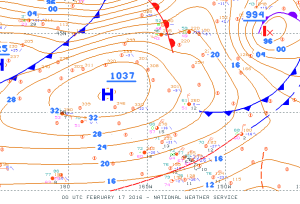
On February 16th, 2016, a 1037mb high northwest of the state brought strong and gusty northeast trade winds to the islands. We received many reports of low-level wind shear, some which we were due to non-convective wind shear and some of which were due to convective mixing and gusty winds. What are the different types of wind shear, when is wind shear included in a TAF, and what can you do to mitigate the risk from it when you fly?
What is wind shear?
Wind shear is a change in wind speed or direction, either in the horizontal or vertical direction. You encounter horizontal wind shear along a cold front, when the wind switches from southerly ahead of the front to northwesterly behind it. You encounter vertical wind shear when you increase in altitude and find stronger winds off the surface. (Wind speeds are lower next to the ground due in part to friction with the land.) In this article we’ll focus on vertical wind shear, or the change in wind with height.
Wind shear can be roughly grouped into two categories: convective/turbulent and non-convective. Convective wind shear is not just associated with shower or thunderstorm downdrafts; it also includes convective (or turbulent) mixing of the atmosphere. Ever notice how the wind tends to be gustier during the day? The sun heats the ground, which warms the air near the surface. The air becomes unstable, rises, and mixes with the air above it. In this situation, stronger winds off the surface may mix down as gusts. Turbulent mixing is also referred to as mechanical mixing, and is the case where stronger winds tend to be gustier. You can compare this to filling a soapy bucket with water from a hose. If you turn the hose on low, you can fill the bucket without creating very much foam from the soap. If you turn the hose on high, you will end up with a lot of foam. This is due to the amount of mechanical mixing, which increases with the force of the water coming out of the hose—or, in the atmosphere, with the speed of the wind.

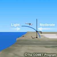
Example of non-convective wind shear associated with a sea breeze. Image courtesy of UCAR/COMET MetEd Program.
Non-convective wind shear is associated with different air masses. One example of this is with an onshore sea breeze: the onshore wind is confined to a small layer near the ground, and once you climb out of it you return to the large scale wind, which may be from a different direction. With convective and turbulent wind shear, you may encounter rapid and frequent changes in the wind. By contrast, non-convective wind shear is longer-lived and typically only changes between two wind directions. However, both are particularly dangerous to aircraft near the ground, which is why this article is focused on low-level wind shear, which the NWS defines as wind shear within 2,000 feet of the ground.
Low-Level wind shear in a TAF
When non-convective low-level wind shear is expected to affect an airport, forecasters will include mention of it in the TAF. (NWS policy is to include wind shear when it is expected to be 30 knots or greater, or if an aircraft reports an airspeed gain or loss of 20 knots.) Taking the example on 2/16 mentioned above, there was a period of time during the afternoon when a small scale eddy caused winds to weaken and turn onshore at Kona International Airport. With strong trade winds just off the surface, this is a prime example of non-convective low-level wind shear. A sample TAF for this situation would be:
TAFKOA
TAF
PHKO 162330Z 1700/1724 20008KT P6SM BKN060 WS010/05030KT
     FM170400 03020G30KT P6SM SCT060
The added element is “WS010/05030KT” at the end of the first line.
WS Wind shear indicator
010 Height of the top of the shear layer (in this case, 1,000 feet)
/ Separator
05030KT Wind direction and speed at the top of the shear layer

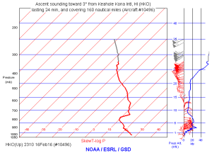
AMDAR sounding from an aircraft departing KOA at 1:10 pm HST 2/16/16 showing strong low-level wind shear. Image courtesy of NOAA/ESRL/GSD.
In this example, the surface wind at the airport is from the south-southwest at 8 knots. At 1,000 feet, the wind is from the northeast at 30 knots. Subtracting the two wind vectors results in a wind shear value of 37 knots, which is more than is needed to be include in a TAF. The “WS” group is only valid until the next FM group; if wind shear conditions are expected to continue, another WS group would be included on the next line as well. However, in this example, the wind shear has decreased because the surface wind at the airport is stronger and more closely aligned in direction with the wind at the higher level.
Mitigating the risk
In Hawaii, it is rare for our airports to reach the 30 knot minimum for non-convective low-level wind shear. Pilots here more frequently encounter convective or turbulent wind shear. While not forecast explicitly, be alert for this type of wind shear when winds are strong and gusty. During the strong trade wind event that occurred on 2/16, we received pilot reports of air speed gain/loss of over 20 knots and many reports of moderate to severe turbulence. Even at Kona, in the late morning before the eddy moved onshore and turned winds to the southwest, winds were from the north-northeast at 23-25 knots with gusts as high as 38 knots. Gusty winds such as these will cause rapid and sometimes drastic changes in air speed, and are particularly dangerous when an aircraft is taking off or landing.
Because non-convective low-level wind shear results in a sustained transition from one wind pattern to another, even if it occurs over a short distance, it is possible to anticipate and react to the change. Pilots can decrease or increase power depending on whether they are gaining or losing air speed. However, with convective wind shear or turbulence, the wind changes are rapid and chaotic, making it nearly impossible to anticipate them. When landing in this type of situation, a pilot may increase power to avoid having the air speed drop below the stall speed if there is a sudden drop in headwind.
Additional observations/examples from 2/16
Non-convective low-level wind shear is typically characterized by either an increase or decrease in wind, but not both:
KOA UA /OV KOA/TM 2054/FL015/TP P3/RM 1/2 MILE FINAL WINDSHEAR +15KTS
Convective or turbulent mixing is typically characterized by a rapid increase and decrease:
KOA UA /OV KOA /TM 2132 /FL001 /TP C208 /RM LLWS +9/-20KT SFC-001 DURD RWY 35 KOA
According to the next METAR observation, the previous PIREP occurred within a few minutes of a peak gust to 38 knots:
PHKO 162153Z 01023G32KT 10SM SCT065 28/15 A2996 RMK AO2 PK WND 01038/2135


Pingback: Wind Shear | Flying In Hawaii