
Note: I originally wrote this article for the General Aviation Council of Hawaii Fall 2011 newsletter. The seasonal outlook no longer applies, but typical impacts during La Niña remain consistent. Hopefully you will still find it interesting and useful. –JB
The fall 2011 forecast [view the latest forecast] from the National Weather Service Climate Prediction Center indicates that La Niña conditions have returned, and are expected to gradually strengthen and continue into the winter of 2011-2012. What is La Niña and what does it mean for weather in Hawaii this wet season?
What is La Niña?
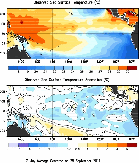
Observed sea surface temperature and SST anomaly from late September, 2011.
La Niña is the cold phase of the El Niño/Southern Oscillation (ENSO) cycle. It is identified by colder than normal water along the equatorial Pacific. It is the opposite of El Niño, which is identified by warmer than normal water along the equatorial Pacific. ENSO episodes typically last 9-12 months, and reach their peak strength during late winter (from December to April). The episodes typically occur every 2-7 years. However, it is not uncommon for a strong La Niña (such as the one that occurred during the winter of 2010-2011) to be followed the next year by a weak La Niña.
The changes in the ocean temperature have wide-ranging impacts on atmospheric circulations and weather patterns.
Weather Impacts to Hawaii
During La Niña years, large scale flow across the eastern North Pacific tends to be more amplified. Instead of a zonal (west to east) jet stream, it can develop more of a north/south component. This amplified pattern can cause storm systems to track farther south than normal. In addition, a persistent upper level high is also common over the Gulf of Alaska. This “blocking” pattern can cause low pressure systems to linger over one area for a prolonged period of time.
At the local scale, Hawaii tends to see above normal rainfall and more frequent storm systems during La Niña years. The winter of 2010-2011 occurred during a strong La Niña. There were many heavy rain episodes, including a number of widespread thunderstorm events. The storms continued into early June, well beyond the typical wet season.
There are a number of aviation impacts that are related to the increased number of winter storms that affect Hawaii during La Niña years. Thunderstorms are more frequent near the islands, with their attendant hazards: severe or greater turbulence, severe icing, wind shear, and IFR conditions. Mountain obscurations are more common and can be more persistent. Widespread icing is possible, and icing conditions can be encountered at lower altitudes.
While these hazards occur regardless of the ENSO cycle, they tend to happen more frequently during La Niña years. The current long-range outlook for Hawaii calls for above normal rainfall and above normal temperatures for the second half of the winter. As the wet season progresses, remember to stay up to date with the latest warnings, advisories, and forecasts from your National Weather Service. If you have questions about any NWS forecast products, you can call the office at 808-973-5286. (Just remember that while we can answer your questions, we can’t provide flight briefings.)
John Bravender
Aviation Program Manager
National Weather Service Honolulu